Reid and I set out early to avoid the heat and the hordes--Sunday was going to be hot and hazy and Camel's Hump is a popular hike. We drove from Charlotte on Lake Champlain along rolling roads that wind past grazing cows, hayfields, dairy farms, fields of solar panels, and small villages. The sun was just rising behind Camel's Hump as we neared. Below are pictures of the summit from across a field in the small town of Huntington--in August and in December.
We reached the parking lot on the west side of the mountain by 7 am; four other cars were already there. By the time we finished our hike at 11 am the parking was full with 28 cars, and more on the way up.
On Sunday, we hiked the 5.8-mile loop clockwise, via the Burrows Trail (2.1 miles), the Long Trail to the peak (0.3 miles), the Long Trail down to Wind Gap (1.9 miles), the Forest City Trail (1.4 miles) to the Connector Trail (0.1 miles). Last winter, Srini, Kodi, I hiked it in reverse. Here is the beginning (or end) of the Connector Trail on the two days, which were decidedly different in temperature and conditions. The temperature at 7 am on Sunday was in the mid-60s and humid, while on Christmas Eve last it was only 5 degrees above zero.
The Burrows Trail is a steady, moderate climb to the Long Trail and the ridge that leads up to the Summit. Many hikers and runners go up and down Burrows for exercise or to catch the sunrise or for the quickest way to the summit.
The short segment of 0.3 miles on the Long Trail to the summit is a bit steeper, but still an easy, quick climb. A sign along the trail alerts hikers to the sensitivity of the alpine zone. We could read the sign on Sunday, not so in ice-covered conditions of December.
The sunrise was just beginning to catch the western slope of the mountain as we approached the summit. Fog hung in the valley and haze obscured the distant views, but overhead was blue sky.
We reached the summit by 8:30 am, in 1.5 hours from the parking lot. Reid stands on the summit with Mt. Mansfield behind him to the north.
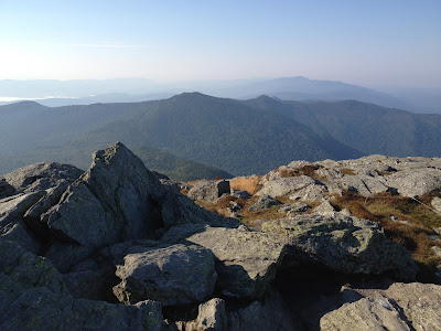
We spent 25 minutes on top, with the summit to ourselves, soaking up the morning sun and taking in the 360 degree view. A wonderful breeze cooled us just right. Despite the haze the views were stunning, including the view south along the ridge and the path of the Long Trail toward Mt. Ellen in the distance.
The summit is rocky (a combination of schist and quartz covered in lichen) with patches of alpine vegetation in between, which are cordoned off with white string, keeping hikers on the rock and off the plants. A chipmunk ventured out from his rocky hideout to look for bits of food dropped by hikers.
By 9:00 am we took in our final views and began the steep descent south along the Long Trail. Both directions require some careful stepping in summer and in winter.
Along the way we looked back at the summit of Camel's Hump. We passed many people on the Long Trail and on the Forest City Trail as they were climbing up; we were happy to be heading down as the heat of the day was rising.
The Long Trail is a windy, up and down trail with steep pitches and narrow slots to climb through. When we hiked the trail in December we paused every so briefly at this sign.
In the lower picture, the sign is on the tree to the right of Srini. The trail was indeed tricky to follow in winter. It was exhilarating to climb it in December and fascinating to see the trail again in summer. I'd recommend this loop as we did it both times: clockwise in summer, counterclockwise in winter. We finished the hike on Sunday in 4 hours, which included 25 minutes on the summit. The winter hike took 6 hours, in part because the Long Trail from Wind Gap to the Summit was not broken out and was icy in a few spots.
A bridge crosses a deep section of Brush Brook at the junction of the Forest City and Connector Trails. This is a lovely spot near the end of the hike. Thanks to Vermonters who maintain the roads, parking areas, trails, bridges, and signs. It is a lovely state for visiting and hiking.


Hi Ellen,
ReplyDeleteHaving just hike to Camel's Hump just over a week ago, I can truly relate to this report.
Your report is marvelous, and I especially liked the interspersing of photos from your winter hike to this fabulous peak!
Have you ever hiked to your namesake peak, i.e. Mt. Ellen?
John
Hi John -- Thanks for your comments. No, I really must hike to Mt. Ellen sometime. Interestingly it is the exact same elevation as Camel's Hump. Have you been there? Ellen
ReplyDeleteHi Ellen,
DeleteNo, I have not been to Mt. Ellen either. I do plan to go there sometime, but it might not be until next summer season. Unfortunately, the trailheads are situated such that it will be nearly a 4-hour round-trip drive for me. So, with the dwindling hours of available daylight, it might be impractical to do it this year. But, we’ll see. Sometimes things have a way of working out, even when you think they won’t! :-)
John