Our base of operations was a friend's cabin, sans electricity, off Bear Notch Road. Upon arrival at the cabin just as it was getting dark we turned on the propane for lights and the stove, primed the outdoor pump to get water for dishes and other uses, checked the mouse traps, fed Kodi, cranked the Greenplay hand crank radio to listen to NPR's All Things Considered, and started fires in the two wood stoves. The temperature inside was 38F, but warmed to 70F within an hour. By the time our friends arrived it was cozy and the lentil soup was hot. A light snow started falling before we went to bed.
Saturday dawned cloudy and windy. Only a light dusting of snow fell overnight. After a drawn out breakfast of coffee, OJ, bagels and cream cheese, hot oatmeal, and cranberry nut bread (there might have been more items), three of us drove up to Lincoln Woods for a hike into Franconia Falls and Black Pond. This was an easy 8+ mile round trip hike on the Lincoln Woods trail along the west side of the East Branch of the Pemigewasset River. The trail follows the bed of an old logging railroad that was last used in the 1940s -- many hemlock ties and spikes are still in place. We passed a couple clearings that were sites of logging camps in years gone by.
Our friend Dale, hiking along the Lincoln Woods trail
Snow-covered rocks in the fast-moving Pemi; view of Bondcliff in the distance
Srini walking across the footbridge that spans Franconia Brook,
at the north end of the Lincoln Woods trail
at the north end of the Lincoln Woods trail
Franconia Falls
Franconia Brook above the Falls
A small, icy stream along the Black Pond trail
View of Bondcliff from the shore of Black Pond
Although the temperature was above freezing, it was a cold day to hike with a steady wind. We needed our winter wear, in part because the trails were so level that we never worked up a sweat. The light dusting of snow, thick bed of leaves on the ground, and a little ice made it a bit slippery in a few places, but bare boot was fine all weekend in the destinations that we chose.
Back at the cabin Saturday night we stepped out to look up at a dark night sky full of stars. So many that it took a few minutes to find Cassiopeia in the Milky Way. We found the Andromeda Galaxy using binoculars -- a hazy patch nearly overhead between Cassiopeia and the Great Square of Pegasus. Jupiter shown brightly in the southeast sky.
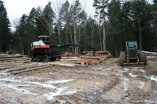
Sunday morning was calm and cold and overcast. This day we climbed Mt. Potash (2,670') -- a new one for us and a repeat for Dale. To avoid a stream crossing, which can be difficult according to the AMC guide, we started at the logging road about 1/2 mile west of the Mt. Potash trail parking lot. We passed a log landing with logging equipment (silent on a Sunday) and piles of logs; farther along we passed one of the recently created clearcuts. This area looks to be actively managed by the Forest Service.
A hundred feet or so past the clearcut we turned onto the Mt. Potash Trail. We climbed through a northern hardwood forest -- the beech here were heavily damaged by beech bark disease; perhaps the reason the area is being cut over time. At about 1,700 feet the forest suddenly changed from hardwoods to a beautiful softwood forest dominated by large, mature spruce, with some hemlock mixed in. A maze of spruce roots criss-crossed the trail, providing good traction as we climbed, allowing us to avoid ice-covered exposed rock slabs.
Sunday morning was calm and cold and overcast. This day we climbed Mt. Potash (2,670') -- a new one for us and a repeat for Dale. To avoid a stream crossing, which can be difficult according to the AMC guide, we started at the logging road about 1/2 mile west of the Mt. Potash trail parking lot. We passed a log landing with logging equipment (silent on a Sunday) and piles of logs; farther along we passed one of the recently created clearcuts. This area looks to be actively managed by the Forest Service.
Logging equipment in the log landing and view of the clearcut with the Hancocks in the background
A hundred feet or so past the clearcut we turned onto the Mt. Potash Trail. We climbed through a northern hardwood forest -- the beech here were heavily damaged by beech bark disease; perhaps the reason the area is being cut over time. At about 1,700 feet the forest suddenly changed from hardwoods to a beautiful softwood forest dominated by large, mature spruce, with some hemlock mixed in. A maze of spruce roots criss-crossed the trail, providing good traction as we climbed, allowing us to avoid ice-covered exposed rock slabs.
About half-way up, the trail follows the top of an exposed rock ledge with wonderful views to the southeast of Mt. Passaconaway, Hedgehog Mtn, and Mt Chocorua beyond. We reached the summit in about 1 1/2 hours, with one set of tracks in the snow our only human sighting on the entire hike.
Srini and Kodi on the Mt. Potash trail looking south to Mt. Passaconaway in the Sandwich Range
The view to the northwest from atop Mt. Potash; the Kanc is just barely visible in middle of photo
The hike to the top of Mt. Potash is an easy, excellent half-day hike. We were back at the cabin for lunch, finishing off some hot soup and chili and wrapping up our weekend at the cabin.


No comments:
Post a Comment