Wednesday, September 26, 2012

Early Fall

Leaves fall in ones and twos,
floating down among the trees, 
to rest among the ferns and partridgeberry.
They float like butterflies
through the dappled light of the understory.
Acorns cover the woodland path like a bed of
marbles; a heavy crop portends a harsh winter,
some say. But that is just a tale for squirrels and deer.
The oak tree responds to weather past, to rain and sun
from a year ago, it does not predict the future.

A gust of wind shakes loose the milkweed seeds, 
blowing them far across the meadow, 
above the last of the yellow goldenrods
and the still vibrant purple asters. 

The wetlands are full of color, the red maples and
blueberry bushes are a riot of red. 
The birches along the edge are yellow in contrast.
A flash of blue and white and then a rattle as a kingfisher
flies across the still waters.
A barred owl calls in the night. Foxes hunt at dawn; 
Kodi notes their passage as he sniffs their trail in the wet grass. 
Hawks soar, butterflies flutter, and warblers chatter as they
make their way south before it gets too cold.

We ready ourselves too, with an extra layer of clothing
and an apple pie. As the tomatoes, peppers, and eggplant fade
from the garden, the menu changes to the autumn bounty,
to kale and squash, carrots and onions, potatoes and broccoli. 
On sunny days, the house is colder than the outdoors now.
All the more reason to be out in autumn's glory.

Friday, September 21, 2012

Life in a Gravel Pit

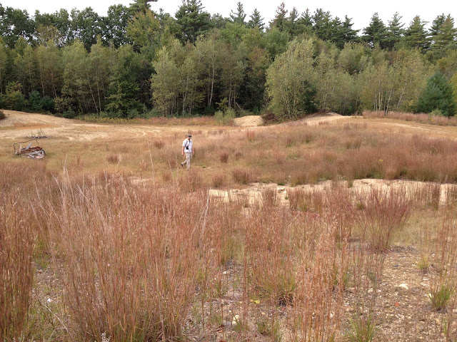
On Tuesday I was out with three colleagues walking through several hundred acres of conserved land. We were there to look at wetlands and turtle nesting areas and talk about how to deal with an old gravel pit. You would think that a gravel pit would be a wildlife disaster area, and it can be if off-road vehicles don't leave it alone.

One of the stewardship issues at this site was blocking people from riding their ATVs through the sandy pit. If such areas are left alone, natural vegetation will grow back and create pockets of habitat for turtle nesting, for small mammals, for insects, and bigger creatures looking for a meal. We could already see this happening in spots as we walked through the undulating topography of the old pit.
Mike Marchand, turtle expert and wetlands wildlife biologist with NH Fish and Game, was with us. He had a keen eye for finding turtle nests in the gravel pit. He showed us nests that were predated on by skunks or raccoons or some other predator, where egg shell fragments were lying about on the surface. When a turtle nest is successful, the eggs hatch underground, and the newborn turtles crawl through the soil to the surface. Therefore, it is easier to detect failed nests because of the shell fragments. Here is one such nest; note the white shell fragments. The other holes appear to be ants or some other insect digging in the soft sand.
Another intriguing find at the edge of the pit, beneath an overhang, were ant lion pitfall traps.
The larval form of an antlion is a scary proposition if you are an ant or other small insect. The antlion larvae digs a small pit about 2 inches across and 1 inch deep. When an ant crawls to the edge of the pit, the antlion, buried in the pit with just its large pincers sticking out, starts tossing up grains of sand to start an avalanche which causes the ant to fall in. After it sucks out the ant juices, the antlion flings the remains of its prey out of the pit. Wow! Good thing this insect is small. And the adult form is a lacy-winged, weak flyer, although I read that they can also give a painful bite.

As we continued our walk about in the gravel pit we saw many dime-sized holes in the sand. Mike and I thought these might be meadow vole holes, but they could be made by short-tailed shrews as the holes were an inch or less in diameter.

Not far from those small mammal hole, we found a depression in the sand and gravel, where a beetle had just de-capitated a wasp.
We saw raccoon scat--one of the turtle nest perps--which I suppose only a wildlife biologist could find interesting enough to post on her blog.
We finally left the gravel pit behind, marveling at the diverse and interconnected (and violent) food web there. At first glance the old gravel pit seemed barren, only a closer look showed otherwise.

Monday, September 17, 2012

The Cannon Tram

For the first time we rode the Cannon Tram to the top of 4,100-foot Cannon Mountain on Sunday. It was a gorgeous early fall day: blue sky, cool temperatures, leaves changing color, a brisk wind on top.
The top--whether you hike or ride--offers spectacular views of Franconia Ridge. North to south the peaks of Mt Lafayette (5,260'), Mt. Lincoln (5,089'), Little Haystack Mtn (4,780), and Mt. Liberty (4,459') were clear. With binoculars we saw a stream of people walking along the ridge.
Atop Cannon Mountain, a short, relatively level path (Rim Trail) leads to an observation platform that provides views in all directions. We could see Camel's Hump on the western border of Vermont in the distance.
As we stood on the observation platform we watched gliders soar silently below us over the Kinsman Ridge and looked down into Franconia Notch.
If you have limited mobility, this is a terrific way to get on top of a 4,000-foot mountain and look out at the mountains and valleys. On Sunday the fall colors were not yet at their peak. Our tram tour guide thought the next 10 days would be the best time to see the fall foliage.

Sunday, September 16, 2012

The Road to Acadia

To reach Acadia National Park we drove north on I-95 to Augusta, then Route 3 east all the way to Mount Desert Island. Route 3 passes through a series of small, inland towns--South China, Palermo, Liberty, Morrill, and Belmont--before reaching Belfast. The sights along this stretch were mostly of houses for sale, boarded up business, and over-harvested forests as far as the eye could see. Beyond Belfast, even the coastal towns of Searsport and Stockton Springs appeared to be faring no better. This trend continued beyond Bucksport, through the towns of Orland, west Ellsworth, and Trenton, at the doorstep of Mount Desert Island.

The contrast between these depressed, rural towns, and the beauty of Acadia and the bustling town of Bar Harbor was stark. There is wealth in this region of Maine, but it is tucked into the coves, rocky hillsides, and discreet, coastal areas. I imagine that some of those folks must reach their homes by boat, avoiding the Route 3 corridor jumble of tourist buses, RVs, cars, bicycles, road crews, and trucks.

We found two state-owned sites along Route 3, between Augusta and Acadia, where we stopped for our picnic lunch. The first was Lake St. George State Park in the town of Liberty. When we entered, the toll gate keeper said we wouldn't like the entrance fee -- $6.00 each for adults and $2.00 each for seniors. It turned out to be a nice picnic spot on the lake, with a large lawn for Kodi to run about (supposed to be on leash we learned later) and clean bathrooms, although $16 to have our own picnic lunch did seem a little steep.

On our return from Acadia we stopped at Fort Knox State Historic Site and Penobscot Narrows Observatory in Prospect. It was another lovely picnic spot--this one overlooking the Penobscot River. During the American Revolution and the War of 1812, the British seized control of the Penobscot River and claimed this very site for the British Crown. As we know, their control of the area did not last, but the United States was concerned that the Penobscot might be attacked again and decided to build a fort.

Construction of the fort did not begin until 1844 and was never really finished and never really used. The large cannons required 12 men to load the 450 pound cannonball; the cannon could fire a solid cannonball 5,579 yards. The fort was built of granite blocks, quarried from Mt. Waldo five miles upstream. By the time the fort was nearly finished, the threat from the British diminished and warfare technology had changed. Still, it is an intriguing site and worth a walkabout.
In 2006 a new bridge was built over the Penobscot River adjacent to Fort Knox. A visit to the fort includes a visit to the Penobscot Narrows Observatory, where an elevator ride takes you to the top of one of the bridge's granite obelisks. The bridge is a "cable-stayed bridge." The bridge deck and cars are supported by a system of wires 1/5 inch thick twisted together into a series of cables.
The historic site offers a span of history from the mid 1800's when the fort was constructed, to the 1930s when the old bridge of the Penobscot was built, to the present day. This is all set within the larger natural landscape of Penobscot Bay and coastal Maine.
The beauty of this landscape and the capacity of humans to engineer infrastructure suited to the times are intertwined at this site. It is well worth a stop to or from Acadia National Park. If only the communities in between could benefit from or build on these natural and man-made features.

Friday, September 14, 2012

Gardens in Northeast Harbor

During our three day exploration of Acadia National Park, we ventured outside the park to visit two gardens in Northeast Harbor: Thuya Garden and Asticou Azalea Garden. Both are maintained by the Mount Desert Land & Garden Preserve. Although small compared to the grandeur of Acadia, they are worth a visit.

As is our habit on trips, we gathered several different maps of the area including the National Geographic trails illustrated map for Acadia National Park, the National Park Service brochure for the Park, and Map Adventures Acadia National Park hiking and biking trail map. The best map of the three was Map Adventures. It showed the topography, the trails, the natural landmarks, the towns, and other interesting sites, including the two gardens.

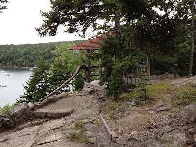
The 140-acre Thuya Garden is tucked into the western slope of Elliot Mountain overlooking Northeast Harbor. Landscape architect and civil engineer Joseph Henry Curtis built his summer home here in the late 1880s. He called it Thuya Lodge after the locally common northern white cedar (Thuya occidentalis). Curtis designed a Terrace Trail leading from the harbor to his lodge, integrating his man-made trail into the natural topography and rock outcrops along the slope.

Here are photos of the path leading from Thuya Lodge down to the harbor.
After Curtis' death in 1928, local resident and landscape designer Charles K. Savage became trustee of the property. For the next 37 years he oversaw the renovation of the lodge and the creation of Thuya Garden in the former orchard next to the lodge.

The Thuya Lodge and Gardens are accessible by hiking up the 1/4-mile Terrace Trail from a parking lot on Route 3 in Northeast Harbor or by driving up Thuya Drive to the entrance of the garden. Thuya Garden is a blend of semi-formal English garden and the natural woodland of the area. The entrance gate is made of cedar and mahogany, handcrafted with 48 carvings of natural history images by Savage and Augustus D. Phillips. Hummingbirds buzzed about us as we walked the mowed lawn along the colorful flower beds.
Paths lead from the more formal garden into the woodlands and through gates to trails beyond, all designed by Savage. A plague on a granite outcrop along one of the paths, recognizes Savage as "Designer of Thuya Garden and its gates, artist in landscaping and woodcarving, lover of books, public minded citizen of community and government, conserver of ledges, trees, slopes for our delight."
One-half mile up the road from Thuya Garden is another of Savage's creations -- Asticou Azalea Garden. Savage created this Japanese stroll garden in 1956. Savage again blends natural vegetation, stones, and water with plantings of azaleas and rhododendrons. Despite its small area, the meandering paths and garden design create an illusion of vast spaces and vistas as well as intimate natural spaces for quiet reflection.
Although we visited in between the flowering time of the azaleas and rhododendrons (mid-May to July) and before the full display of fall colors, we enjoyed strolling through Asticou. A busy Route 3 was a stone's through away and yet it seemed far away in time and space once we entered the garden.


Thursday, September 13, 2012

Acadia National Park

We just returned from a three-day exploration of Acadia National Park and Mount Desert Island. On Sunday we drove along the 27-mile loop road, under gray skies. The high surf crashed against the rocky shore and the thick evergreen forest along the road darkened our entry into the park. Wind whipped our jackets as we stood on Sand Beach -- the only sandy beach along the Park's coastal shore.
Monday morning we woke at daybreak, the sun streaming in the windows of our small cottage rental. A new day with bright and beautiful weather. We drove to the top of the 1,530-foot Cadillac Mountain along the 4-mile historic road to catch the morning rays as they touched this highest point on the Atlantic seaboard.
In the distance the tip of Schoodic Point was bathed in the morning light.
We stood on the top of the bald summit, just as the French explorer Samuel de Champlain saw it in 1604, prompting him to name the island "Isles des Monts Deserts." But the island is far from a barren desert (it is also worth noting that deserts are actually not barren either).

The beauty, diversity, and geologic history of Acadia reveals itself as you explore the trails, shoreline, coves, rocky summits, forests, and lakes. It offers dramatic rocky shores and quiet, woodland paths, places to observe, think, and reflect. The summit of Cadillac Mountain was only the start of our own exploration. Every direction offered awe-inspiring vistas.
Here we look northeast to Bar Harbor, Bar Island and the four porcupine islands in Frenchman Bay.
A view south to the great expanse of the Atlantic Ocean.
A walking path loops around the summit with sweeping views and close-ups of the granite summit and wildflowers--including goldenrods and cinquefoil--tucked into sheltered crevices.
Jordan Pond is a popular destination in the Park. Many visitors stop at the Jordan Pond House for tea and popovers. Under a brilliant blue sky we opted instead for a hike along the eastern shore of the pond. The trail was flat and scenic, lined with northern white cedar and red spruce. The water was clear. North and South Bubble mountains dominated the view at the north end of the pond, while the long, sloping Penobscot Mountain stretched above the western shore of Jordan Pond.
North and South Bubble and the clear waters of Jordan Pond
Penobscot Mountain above the western shore.
Northern white cedar grows along the shore.
The rocky shores of Acadia National Park are dramatic: the surf crashes against the Ellsworth schist, breaking off bits or large blocks over time. The waves rush into rocky coves, sloshing and spraying, and roaring like thunder. The views are stunning.
There is so much more to Acadia than we had time for on this trip. A network of footpaths and carriage roads lead away from the main thoroughfares. Someday we'll return and wander down some of those paths.

First Walks of 2024

We rise early, well before sunrise. It helps to go to bed early. Fortunately the New Year's Eve celebratory fireworks in the neighborhoo...